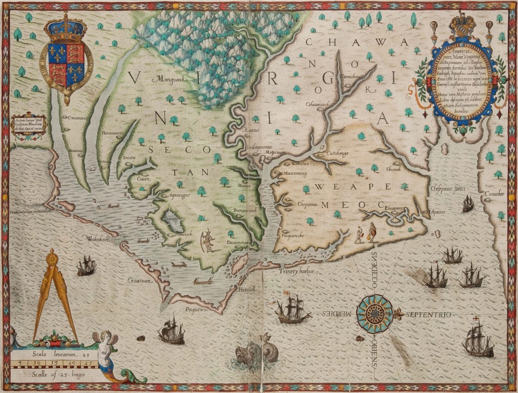
Americae pars, Nunc Virginia, engraved by Theodore De Bry; after work by John White, Frankfurt, Germany, 1590, black and white line engraving with period color, gift of the Virginia Cartographical Society.
WILLIAMSBURG, VA. — The Colonial Williamsburg Foundation has acquired a notable collection of early Virginia-related maps. Through a part gift/part purchase agreement, the foundation has added more than 220 maps, charts, atlases and documents to its collection, all dating between 1540 and 1835.
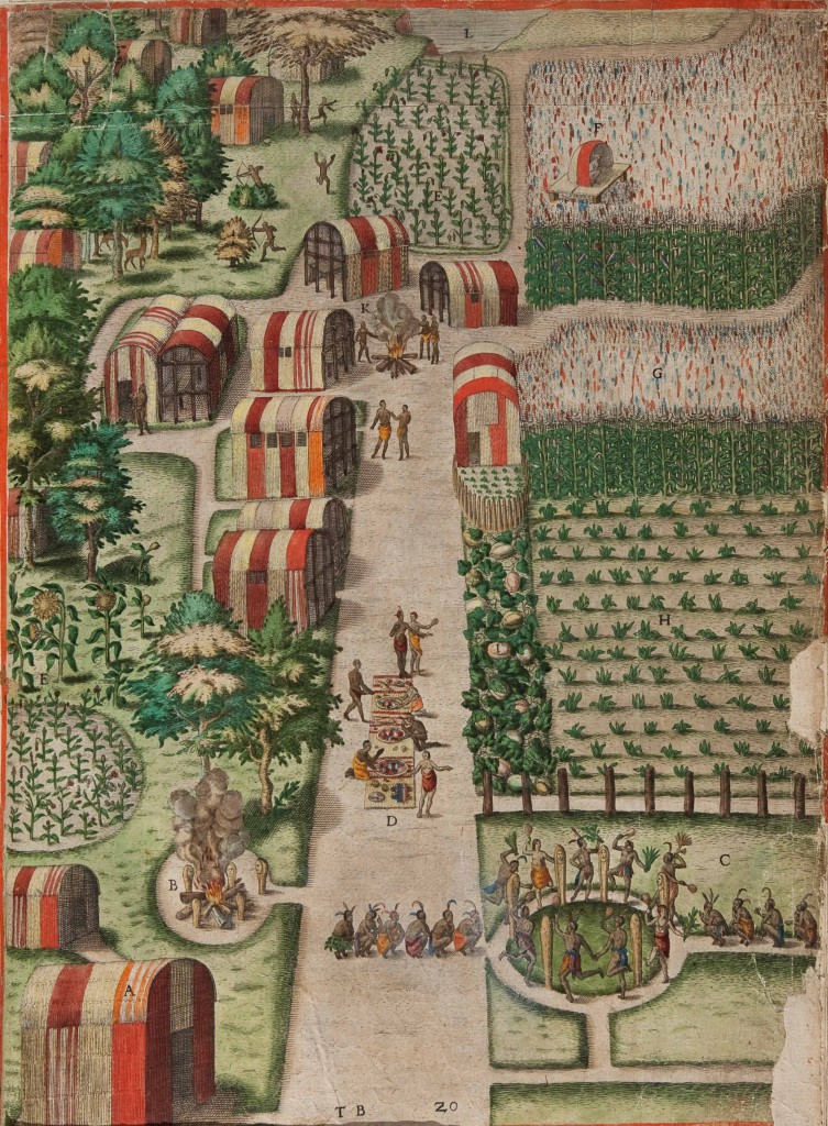
The Town of Secota, engraved by Theodore De Bry; after work by John White, Frankfurt, Germany, 1590, black and white line engraving with period color, gift of Virginia Cartographical Society.
Collected over four decades by William C. Wooldridge of Suffolk, Va., the maps were until recently owned by the Virginia Cartographical Society, a private, Norfolk, Virginia-based consortium. The addition of the Wooldridge Collection gives Colonial Williamsburg the most comprehensive assemblage of Virginia maps outside of the Library of Congress. These objects will be displayed in multiple future exhibitions at the Art Museums of Colonial Williamsburg and will be made available this spring through the foundation’s online database at www.history.org/museums.
“We are thrilled to announce this landmark acquisition, which represents a critical investment in the Foundation’s core mission to advance the public’s understanding of early America and its inhabitants,” said Mitchell B. Reiss, president and CEO of Colonial Williamsburg. “The maps contained in the Wooldridge Collection — in addition to being true works of art in their own right — offer extraordinary insight into the exploration, settlement and development of Virginia.”
“Maps are among the most illuminating of artifacts because they reveal the interests, aspirations, and even biases of those who made and used them,” said Ronald Hurst, Colonial Williamsburg’s Carlisle Humelsine chief curator and vice president for collections, conservation, and museums. “When paired with the foundation’s early Virginia maps, the Wooldridge Collection gives us an unparalleled ability to understand and share Virginia’s role in our national story.”
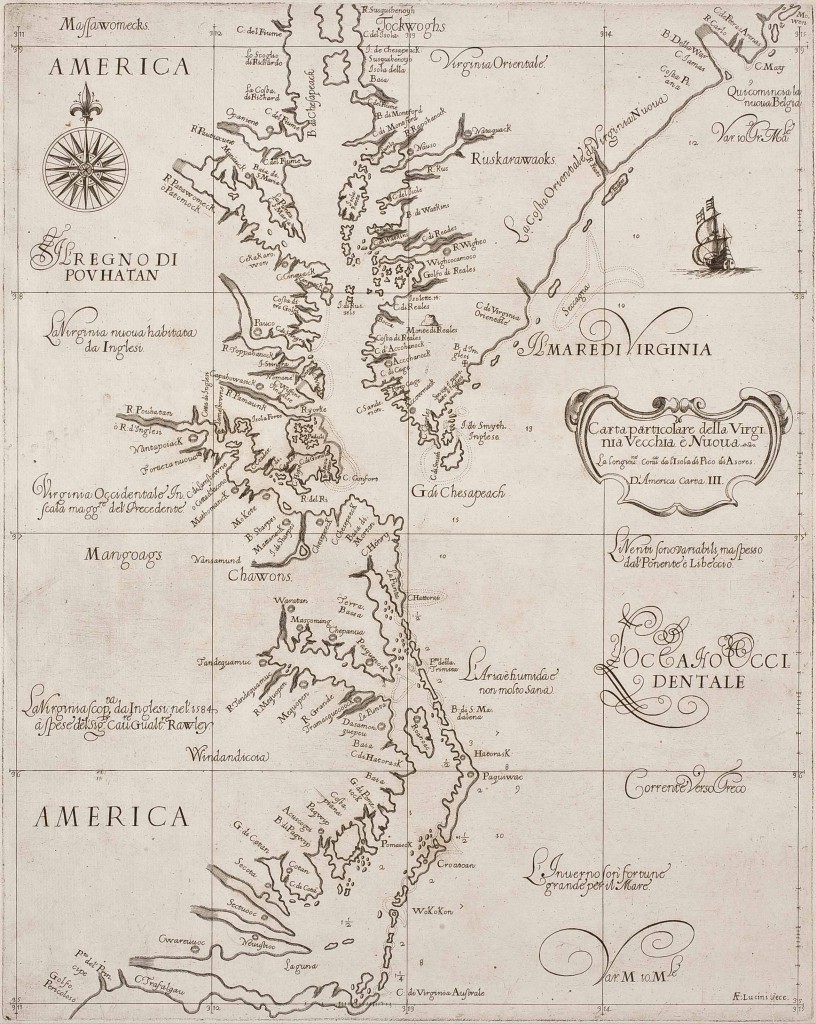
Carta particolare della Virginia Vecchia è Nuoua, Sir Robert Dudley, cartographer; engraved by Antonio Francesco Lucini, Florence, 1647, black and white line engraving, gift of the Virginia Cartographical Society.
Maps were made for a variety of reasons: to document new discoveries, facilitate travel, claim land and record military activity. This collection contains numerous examples of each type. One visually standout map in the Wooldridge collection was made to facilitate travel. Carta particolare dela Virginia Vecchia e Nuova by Sir Robert Dudley was published in Florence, Italy, in 1647, and was the first map to depict the region using Mercator’s projection (to flatten the spherical shape of the earth on paper required increasingly distorting the lines of longitude the farther they were from the equator so that lines of longitude and latitude were at 90° angles. Although the land formations were altered, navigators could draw a straight line between any two points), which provided a practical aid for navigators.
Also in the Wooldridge Collection is a rare copy of Thomas Harriot’s 1590 publication, Admiranda Narratio fida tamen, de Commodis et Incolarum Ritibus Virginiae, with engravings by Theodore de Bry after John White in original color. De Bry’s engravings portray Virginia as a latter-day Eden, perhaps to stimulate interest in settlement. The Native American “Town of Secota” depicts such a scene, showing an abundance of thriving crops in neatly ordered gardens carefully manicured by a native population.
The map of Americae Pars, Nume Virginia drawn by John White and engraved by de Bry provides the first printed English record of Sir Walter Raleigh’s attempts to plant a colony in the New World. Although described in the title as Virginia, it delineates the region between the mouth of the Chesapeake Bay and Cape Lookout, North Carolina.
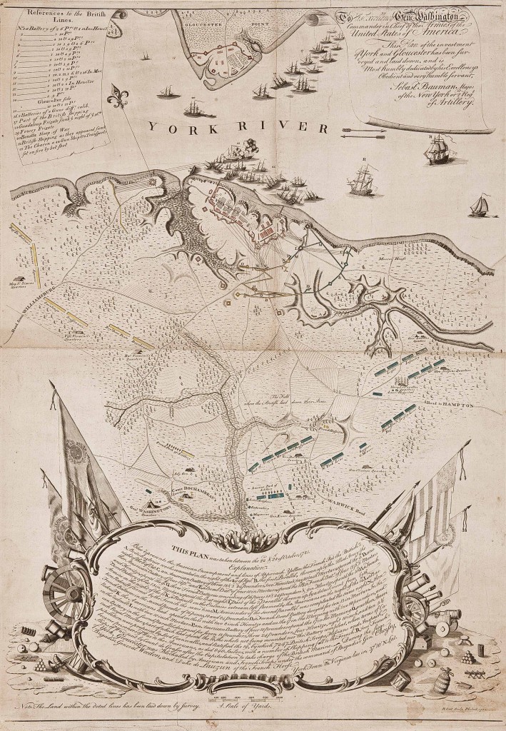
Plan of the Investment of York and Gloucester, surveyed by Sebastian Bauman; engraved by Robert Scot, Philadelphia, Pennsylvania, 1782, black and white line engraving with period color, gift of the Virginia Cartographical Society.
Another highlight among the new acquisitions dates to the close of the American Revolution in 1781. Immediately after the British surrender at Yorktown, each of the generals enlisted their engineers to create surveys of the battlefield. The most engaging of these, Plan of the Investment of York and Gloucester, was produced by George Washington’s engineer, Major Sebastian Bauman (who served as artillery commander at West Point in 1779 after emigrating from Austria). In addition to providing substantial, detailed military information, this map is interesting for its artistic composition. Yorktown, Gloucester Point, and troop positions are confined primarily to the top half of the map. The lower half is dominated by an explanation embellished with ornaments of war. The shape of the scrollwork cartouche surrounding the explanation, with flags and banners that thrust upward from both sides, forces the eye to the center of the image. Here, in an open space, is the very heart of the map: “The Field where the British laid down their Arms.”
Map aficionados, American history scholars and students in addition to anyone interested in early Virginia will find this newly combined collection a must-see resource. The addition of the Wooldridge Collection to Colonial Williamsburg’s existing holdings cements the significance of the Art Museums of Colonial Williamsburg as the premier destination for the study and appreciation of early American artifacts.
The Art Museums of Colonial Williamsburg are at the intersection of Francis and South Henry Streets.
